Garmin Aviation GPS Units: Awareness in Your Hand
The global positioning system is also known as GPS has been around since 1973. This system of satellites orbiting earth has been a crucial component of mapping our planet and guiding pilots too. There are 31 satellites at an altitude of around 17,700 km that provide every driver, pilot and ship captain with the information of their positioning and what lies ahead. Today, the global positioning system is more readily available to more people and on more devices while being more advanced than ever. Getting the hang of operating an airplane is easier today, especially for new pilots, in part due to GPS systems. With GPS devices being as small as a handbag you can easily maneuver a plane with the latest maps on deck. The most advanced and efficient GPS navigational devices come from Garmin, a manufacturer that has been making these kinds of devices for years now.
How Accurate is Garmin GPS?
While the accuracy of a portable GPS device depends on the type of technology it uses, for most Garmin devices the accuracy is as high as 95%. Garmin navigation is so advanced and it can locate and track you with accuracy within 15 meters, and sometimes it can go down to 10 or 5 meters of where you are. This level of accuracy is achieved under normal conditions.
Does Garmin GPS Use Data?
While Garmin airplane GPS devices that are compatible with the Garmin Pilot app use data to help you navigate, those that are not compatible with it don’t. This depends on the type of Garmin device you have as not every single one is compatible with the app, especially not older ones.
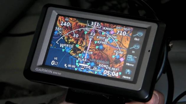
Aera 500
Aera 500 is one of the most popular Garmin devices when it comes to GPS navigation. It comes with a 4.3-inch touchscreen display, is IPX7 rated, weighs 270g and has a resolution of 480×272 pixels, and a battery life of up to 5 hours. Alongside its internal solid-state memory drive, you can also make use of an SD card since the Aera 500 comes with a slot for external memory storage. The GPS receiver of the Aera 500 has a nominal operating velocity range from 0 to 800 kts which is equivalent to 411 m/s.
Furthermore, the Aera 500 comes with VFR and the ability to have up to 3,000 waypoints and 50 different routes. The fast 5 GHz refresh rate screen coupled with full and ARTCC, FSS frequencies and final approach waypoints of JEPPSEN data gives you the best performance found on this small Garmin GPS aviation unit. The Aera 500 is only 8.4 cm tall and 13.5cm wide. Lastly, the Aera 500 has a standard terrain resolution and it comes with an automatic logbook, smart airspace feature, and GPS-based HSI.
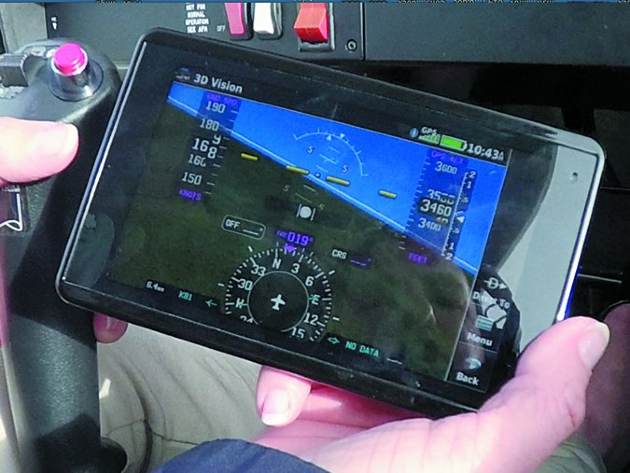
Aera 660
With the Aera 660, you get a bigger Garmin navigation device but also a bigger battery. The Aera 660 can last you one extra hour and despite being bigger than the Aera 500 it weighs only 245g. With a higher display resolution of 480×800 pixels, the 5-inch touchscreen display makes for great viewing angles. This is also a VFR-ready device that can also display traffic information services.
Like the Aera 500, the Aera 660 also has an SD card slot. The Aera 660 is better at flight mapping and it offers more info on weather and traffic without the use of any wires with the help of an app called Target Trend. The Aera 660 also gives you a 3D perspective with Garmin’s revolutionary vision technology and the use of both GPS and GLONASS systems. The Garmin Aera 660 comes with an SBAS/ WAAS/ GLONASS receiver which allows for high-sensitivity positioning accuracy. Lastly, this model has a voltage range from 10 to 35V and the same high sensitivity position accuracy as the Aera 500.
Aera 760
If you want to get the best of flight navigation available, you should consider getting Garmin’s Aera 760. This 561g heavy device comes with a 7-inch display at a resolution of 480×800 and a battery life of 4 hours. What’s impressive for the Aera 760 though is the fact that it can use both VFR and IFR route data and lets you know of any obstruction below you such as wires. The screen of the Aera 760 is clearly visible in direct sunlight and the unit itself offers dynamic maps and the creation of flight plans too.
You also get cockpit integration, map topography, comm connection and Garmin’s SiriusXM service. 3D vision is also present as well as the smart airspace service, terrain altering, access to ADS-B data links, and the target trend tracking app. The Aera 760 comes with the latest USB-C connection port and a rechargeable lithium-ion battery. This device is made so that you can add waypoints, arrivals, and airways easily thanks to the direct-to navigation that comes built-in on the Aera 760.